lördag 24 december 2011

Is the Gulf stream getting weaker? Part I

The characteristics of water are as I said relatively unique. The fact that it is at its heaviest at +4 degrees Celsius is one reason for the formation of the Gulf Stream.

The Gulf Stream is a crucial part of Earth's complex system of air and water currents. It brings the hot water from the area around the Gulf of Mexico, which has given it its name all the way up to the waters east of Grönland. On it’s way north in the Atlantic sea it passes the North west coast of Africa, British Isles, west coast of Norway and Iceland.

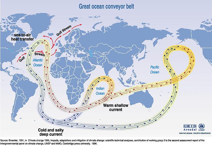
Once up in the Arctic the stream is cooled off. The lower temperature means that the water may have get higher salinity. Low temperatures and high salinity increases the density of the water and it begins to sink. When the water sinks towards the bottom it creates space for new water on the surface and presto, we have one of the driving forces behind the formation of the current.

More will come

tisdag 20 december 2011

Madden Julian Oscillation(MJO) and the El Niño-Southern oscillation(ENSO)

There is strong variability in MJO activity from year to year. There are long periods of strong activity followed by periods in which the oscillation is weak or absent.

This interannual variability of the MJO is partly linked to the ENSO cycle!!

In the Pacific, strong MJO activity is often observed 6 – 12 months prior to the onset of an El Niño episode, but is virtually absent during the maxima of some El Niño episodes.

MJO activity is typically greater during a La Niña episode. Strong events in the Madden–Julian oscillation over a series of months in the western Pacific can speed the development of an El Niño or La Niña but usually do not in themselves lead to the onset of a warm or cold ENSO event.

The westerly surface winds associated with active MJO convection are stronger during advancement toward El Niño and the easterly surface winds associated with the suppressed convective phase are stronger during advancement toward La Nina.

But it is not the MJO that creates El Niño and La Niña, there is only a correlation between the ENSO and the the status of the Niñas!?

Read more about how NOAA follows the MJO activity to help them in the forecasting

måndag 19 december 2011

Why is it more windy during winter?


The difference in air pressure between the Equator and North Pole is at its highest during midwinter. Then the air over the North Pole is at its coldest and heaviest, while it is still summer warm over the Equator. When the air in the north is at the coldest and heaviest, the kinetic energy towards the high pressure in the south is the greatest and we get stronger winds than during our summer half year when the differences in temperature are smaller.

Wind occurs because of pressure differences in the air. These pressure differences are created by air temperature differences. We get temperature differences in the atmosphere because the earth is spherical and therefore the solar radiation has different approach to the Earth's surface. In the northern hemisphere, the angle between the sun and the earth's surface reduces the further north one travels. Therefore, it is warmer at the equator and colder at the poles.

In the atmosphere there is high pressure and low pressure created by the difference in temperature of the air masses in different areas. When air masses move from areas of high pressure to areas of low pressure winds occurs. The greater the pressure difference is the harder it blows.

Solar heating is unevenly distributed over the earth and the wind is trying to smooth out these differences in temperature. Therefore, the wind blows more in the fall and winter in our part of the world, when very cold air has formed at the North Pole, while air masses in the south are still summer warm.

There are different types of high pressure. Stationary high pressures are warm and created over large sea areas while the seasonal high pressures are cold and occur during winter over the northern continents. Variable high-pressures occur in connection with the migratory lows. It is the seasonal high pressure that creates cold winds from north to south.

Madden-Julian Oscillation and cyclical changes in wind direction

In the early 1970s, the American meteorologists Roland Madden and Paul Julian discovered a wide area with enhanced thunderstorms and rains, which, are constantly on the move eastward around the equator and also creates changes in wind, air pressure and temperature.

In other words: There's a weather system travelling around the Earth on and on and on.

The Madden-Julian Oscillation moves, eastward at a speed of 5-10 m / s. It takes 30-60 days for it to complete one lap and the phenomena is most noticeable in the Indian Ocean and Western Pacific.

After the explosion of the volcanic island of Krakatoa in the Indonesian archipelago in 1883 one could observe how the dust pushed westward around the equator at 30-50 km altitude. 25 years later the Polish-German meteorologist Arthur Berson observed, when he was flying in his balloon in East Africa, that it began to push eastward when they reached 15 km altitude.

The fact that these two wind systems were really the same was discovered first in 1957-58 during the British atomic bomb experiments on Christmas Island, where extensive wind measurements were made.

Thus, it was discovered that the winds around the equator in a layer between 15 to 50 km alternates between easterly and westerly direction with an approximal periodicity of 26 months. Why the wind switch direction in this way and in addition why every twenty-sixth month, no one has really been able to explain yet!!! Anyway, the phenomena is called Quasi-Biennial Oscillation (QBO)

fredag 16 december 2011

Weather prediction helped by Madden Julian Oscillation

In the tropics, weather is not as predictable as in mid-latitudes. That is because in mid-latitudes the weather variables (clouds, precipitation, wind, temperature, and pressure) are largely governed by the upper-tropospheric so called Rossby waves, which interact with surface weather. In the tropics there is no such dominant instability or wave motion, and therefore the weather is less predictable for the 1-10 day period. Until recently it was believed that tropical weather variations on time scales less than a year were essentially random.

In 1971 Roland Madden and Paul Julian stumbled upon a 40-50 day oscillation when analysing zonal wind anomalies in the tropical Pacific. They used ten years of pressure records at Canton and upper level winds at Singapore. The oscillation of surface and upper-level winds was remarkably clear in Singapore. Until the early 1980′s little attention was paid to this oscillation, which became known as the Madden and Julian Oscillation (MJO), and some scientists questioned its global significance. Since the 1982-83 El Niño event, low-frequency variations in the tropics, both on intra-annual (less than a year) and inter-annual (more than a year) timescales, have received much more attention, and the number of MJO-related publications have grown rapidly.

onsdag 14 december 2011

The Humboldt Current binds CO2 and creates life!

The Humboldt Current carries cold water with low salinity from the South Pacific towards the equator. It makes the photosynthesis in the water to flourish. More than 300 grams of carbon, per square meter and year, is converted into organic material. This area is the most productive ecosystems in the world.

It also brings back nutrients, that has been released when degrading organic tissue from dead algea, fich etc, from the ocean floor to the surface.


The Humboldt Current thus contributes to the big fishing industry in the area. Just under a fifth of the World’s fish catch has its origin in the area affected by the Humboldt Current. These are species of fish such as sardines and anchovies.

A rough estimate says tat the water that covers the Humboldt Current corresponds to the size of Australia. These waters would than bind the same amount of CO2 corresponding to what half of all the cars on Earth emit per year!

When the current functions normally one can in a sustainable way fish about 14 million tonnes of fish per year. The (unsustainable) annual fish catch in the World is at about 130 million tonnes.

Years with El Niño, when the Humboldt Current does not reach sea level and the ecosystem collapses, the binding of CO2 will decrease to such levels that the increase of CO2 in the atmosphere is noticeable.

Could it be that now that we have two El Nina in a row, we will be able to notice a reduction of CO2 in the atmosphere? And life would grow strong in the east Pacific Ocean??That would be really exciting!

tisdag 13 december 2011

Why do not the coniferous trees fell their needles in the autumn?

Because a needle is completely different than a leaf. It has thick walls, is better to keep the fluid level in the cells etc. If they loose fluid level/-pressure, the do not collapse because they are stiff and can therefor handle a dry season better than a hardwood.

Coniferous trees drop an entire group of needles, with the same age, at a certain time during the year. Scandinavian Spruce for example, let their cohort in late winter. I remember that especially well as my first ski race took place in late March in northern Sweden. My dad had waxed my skis with silver paste wax. It looked very nice under the skis before I started "skiing" around among the needles. The skis did not slide an inch, but I had to walk around the one mile long track. It took years before I appreciated skiing again.

But how do the needled prevent themselves from not freezing and burst? Because they reduce the water volume to a certain point and increases the concentration of both sugar and minerals to get a glycolic effect, and thus lower the freezing point of water

fredag 9 december 2011

Is the Green House Effect creating more frequent El Niños or not?

Once again: The sun is warming up the Earth, the Earth is warming up the atmosphere.

Climate research mean that the increasing concentration of CO2 prevents the heat radiation from leaving Earth which results in an increased temperature in the atmosphere.

The Greenhouse effect provides a warmer atmosphere. The warmer atmosphere, air heated by the Earth, would not rise as fast then it would through an atmosphere with normal temperature? This in turn could make the Walker circulation weaker and thus the Trade winds. The hot water that normally runs westwards would have easier to run back east. The risk of more frequent El Niños would be clear!?

Is it instead that the sun heats up the land and water more then normal? The water is heated by the sun and the “mountain of warm water in the west would be too big and physically start to move eastwards? This could perhaps also disturb the Walker circulation to the east. Then the creation of more frequent El Niños, is more about the sun’s ability to increase the water temperature and physical phenomena creating the El Niño rather than a warmer atmosphere?

Nevertheless, the increased amount of CO2 in our atmosphere is only one very critical effect of human activity. All the other effects humans have on fresh water, deforestation, air pollution in general are all very critical and needs to be addressed. The focus on Global warming helps making people aware of all these questions, and that is maybe the most important when we discuss CO2?

onsdag 7 december 2011

Does the Walker circulation create the Trade winds or vice versa?

At the end of the 1960s the Norwegian-American meteorologist Jacob(Jack) Bjerknes was the first to  link variations in the tropical Pacific Ocean with large-scale motions in the tropical atmosphere and the appearance of El Niño.

Note that we are talking about the atmosphere above the prevailing weather (if one may say so). These movements are one of the strongest driving forces behind the Trade Winds.

During a normal year with warm water over the Indonesian archipelago and the colder waters outside South America, a gigantic sea breeze-like circulation(Walker cisrculation) with ascending air (low pressure), prevails over the western Pacific equatorial parts, and the opposite, falling air in the east (high pressure).

When the hot water during an El Niño episode spreads eastward, also the Walker Circulation moves eastward. This in turn affects the circulation over Africa and South America and thus most of the tropics.

What the scientists appear not to agree upon is whether it is the water masses fleeing eastward which makes the Walker circulation to move, or vice versa. This may well be a running point when reasoning about climate change and El Niño.

tisdag 6 december 2011

Sothern Oscillation found by Hildebrandsson, Walker and Bjerknes?

The effect on the winds sea currents by the Earth's rotation, the Coriolis effect, is weak near the equator where the dominant movement is rising heated air; convection. It can therefore be led to believe that the tropical circulation is fairly straightforward, as an unstable Swedish summer day, but with larger and heavier showers. But no, the tropical atmosphere is full of strange phenomena, which often gets stranger the closer to the equator we come.

Being in the middle of your 50-years crisis? The meteorologists Hugo Hildebrandson (1838 - 1925), Gilbert Walker (1868-1958) and Jack Bjerknes (1898-1974) all made epoch-making discoveries when they were well over 50.

In the late 1890s Hildebrandsson discovered strange, slow and large-scale atmospheric pressure variations, particularly in the Pacific Ocean. Months with high air pressure over Indonesia / Australia were found to be associated with low pressure over South America and vice versa. Walker followed the path of Hildebrandsson and mapped in the mid 1920s in more detail this phenomena, which he called, the Southern Oscillation.

In 1969, Jacob Bjerknes helped toward an understanding of El Niño Southern Oscillation, by suggesting that an anomalously warm spot in the eastern Pacific can weaken the east-west temperature difference, disrupting trade winds, which push warm water to the west. The result is increasingly warm water toward the east

söndag 4 december 2011

What creates El Niño and La Niña?

What are the reasons behind the fact that the currents in the Pacific ocean are oscillating/changing at irregular intervals? Is it the changes in the strength of the dominant/most common air currents, water currents or has the Earth's rotation a big impact?

Some climate scientists have linked the past twenty years, more frequent and stronger El Niños with the air current changes due to global warming of the atmosphere. With a warmer atmosphere the relative power/speed of the rising hot air from the earth/oceans becomes weaker. Winds would then be weaker and reduce the drive of the water flow westwards

If it is an imbalance in the water system, which leads to El Niño, it is more difficult to find a connection to the global warming of the atmosphere. It is the sun that warms the ocean surface and if the warming shifts/oscillates, it would rather be due to changes in solar radiation intensity? El Niño would then be created because the amount of warm water in the west is too big, "the water mountain will be too high" and would begin to drift eastward physically.

Is it the rotation of the earth that creates the changes in ocean currents the picture becomes yet another. It is the rotation that together with the trade winds keep the hill of warm surface water to prevent it from sliding to the east. The so-called Coriolis power is an effect of Earth's rotation, and is according to researchers the power that prevents the giant sea mountain, created by the trade winds, to move eastwards. The difference of the height on the “warm water mountain” is as much as 45 cm, compared to normal sea level, but the volume is huge.

fredag 2 december 2011

La Niña and El Niño

Is it the changes in the air or water currents that create the El Niño? Or is it perhaps the earth rotation? The question seams to be impossible to answer.

Trade winds create a slight uphill of warm surface waters to the west. With 4-8 years cycles, the trade winds get weaker and the slope slides back eastwards.

El Niño occurs at irregular intervals between 4-8 years. Opposite, La Niña, which is actually a strengthening of the normal state occurs in between. This happens when westerly trade winds are stronger and drives warm surface water westward.

With El Niño, more warm water then normal reaches the west coast of South America, This prevents the cold Humbolt current from reaching the surface along the coast which changes the whole ecosystem. Fishing is poor, coral reefs could die. On land, the normal condition is a dominant high-pressure with low rainfall as a result. During El Niño low pressures become more frequent and Chile and Peru will be hit by torrential rain(downfall). On the other hand, Indonesia and Australia's eastern parts get severe drought.

 La Niña affects the climate in the opposite way. The Humbolt current will function normally, it will be a very stable high pressure over Chile and Peru as well as strong low pressure in Indonesia and eastern Australia.

The big winds and water currents in the Pacific Ocean

First of all I, these huge wind and water systems are not stable. There exists a standard pattern, but with almost continuous deviations. But you have to start from a template and then possibly describe the differences as you go.

The Earth's rotation creates the dominant / most common wind direction in the tropics from east to west and leads the tropical ocean currents westward. In the Pacific we find North and South Equatorial Current leading surface waters westward. However, approximately 5-10 degrees north of the equator in a belt that is relatively calm, the Equatorial maelstrom travels east in a narrow band. The current extends over the entire ocean from the Philippines to Colombia.

The explanation for this phenomenon is to say the least extraordinary. When the easterly trade winds drive the warm surface waters westward, a sort of flat slope of warm water is formed which is highest in the west. The trade winds are holding back this slope so that water can not slide back "downhill". But there is a narrow gap in the prevailing east wind, where the winds are weak and changeable, and there can the water freely flow downhill to the east.

torsdag 1 december 2011

The basic forces in the Pacific Ocean

Under normal conditions, the relatively strong trade winds blow from east to west along the equator in the Pacific Ocean. The bulk of the warm surface water run in this way westwards from South America's coasts against Australia and Indonesia.
As warm surface water drives towards the west, it creates space for the cold water from the Humbolt current to flow up along the main Chilean and Peruvian coasts. This cold water is very nutritious and it creates the conditions for a frenetic biological activity. Both through photosynthesis, which creates a lot of plankton, necessary for higher life forms. There are figures indicating that approximately 20% of the world's catches of fish comes from these waters.

Then a lot of interesting things take place in the water and air and at irregular intervals arises El Niño and La Niña and many other fascinating phenomena